created 13/3/96, modified 28-10-2016 by Dutyhog.
Your browser doesn't use stylesheets, or has turned off the use of our stylesheet. Although you won't get the page design we intend, you should still see all of the contents and links, in a reasonable order of appearance.
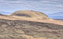
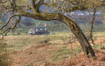
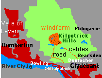
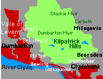
Clydebelt is dedicated to retaining and enhancing our heritage and the green belt status of the Kilpatrick Hills and their surrounding environment in Clydebank, Dumbarton, Milngavie, Bearsden and Glasgow.
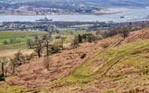
Clydebelt is concerned with other undeveloped areas nearby, including the north bank of the River Clyde, and in the "villages" of Old Kilpatrick, Dalmuir, Duntocher, Hardgate, Faifley, Drumchapel, Craigton, Carbeth, Gartocharn, Jamestown, Bonhill, Milton and Bowling.
Many values and attitudes are shared by members.
What does Clydebelt do? Campaigns on current issues, helps local communities and influences planning policy.
How to contact Clydebelt or join Clydebelt.
How to get Clydebelt news
People who join Clydebelt are emailed news and a magnificent newsletter, as well as being able to join the Clydebelt Facebook Group
Archived stories
The early history 1990-2009 of Clydebelt is archived on this web site.
There is more recent history at: 2009-2012 blog site for Clydebelt News
and 2012-2015 Clydebelt News - Kilpatrick Hills & surrounding towns ...
See or download Clydebelt's 1991 to 2015 Newsletters:
Kilpatrick Hills campaigns
Clydebelt started in 1990 - 400 opposed a huge planning application. We've run many Kilpatrick's campaigns since - eg Windfarm on Kilpatrick Hills?
Helping local communities
Clydebelt has helped with Communities' issues in other places near to the Kilpatrick Hills.
Influencing planning & policy
Clydebelt tries to influence planning & policy, on development, access etc. We helped form the Scottish Green Belts Alliance. The Glasgow & Clyde Valley Structure Plan heeded our objection to windfarms on the Kilpatrick Hills.
-
Subscribe to our emails for the latest news
or join the Clydebelt Facebook Group
We usually meet on the third Tuesday of alternate months - members will be emailed.
At the 2013 AGM it was agreed that a one off membership fee of £5 per household should be paid. Previous payments lasted for 24 years! Cheques made out to Clydebelt, with particulars and email if possible, can be sent to ELIZABETH PITTS, FAIRHILLS, STATION ROAD, OLD KILPATRICK G60 5LT
GET YOUR MEMBERSHIP NOW - EMAIL US IF YOU WANT TO BECOME A MEMBER
Scottish Wildlife Blog on Kilpatrick Hills run by Teresa Dockery